Tuesday 21 / July / 2026

Muscat: After the tropical state has developed into a first-class tropical cyclone, here is a look at the potential impact on the Sultanate.
Indirect effects of 'Shaheen' begins : CAA
The Civil Aviation Authority (CAA) said that the indirect effects have begun on the coasts of the governorates of South Al Sharqiyah and Muscat.
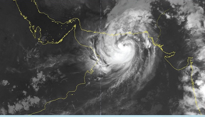
“The latest satellite images and analysis of the National Multi-Hazard Early Warning Centre indicates that the Tropical Cyclone Shaheen is currently focused on latitude 24.2 degrees north and longitude 61.8 degrees east, and continues its movement towards the coasts of the Sultanate overlooking the Sea of Oman. While the nearest cumulus cloud is 190 km away, the wind speed around the centre is estimated at 64 to 75 knots (116-150 km/h),” CAA said in a statement.
The indirect effects began on the coasts of the Governorates of South Al Sharqiah and Muscat, with waves at a height of three - five metres with the flow of clouds accompanied by rains of varying intensity. The direct effects will begin tomorrow morning, Sunday, and will be accompanied by high speed winds (30 to 60 knots and very heavy thunderstorms (200 to 500 mm), leading to flooding of the valleys of the governorates of North Al Batinah, South Al Batinah, Muscat, Al Dhahirah, Al Buraimi, Al Dakhiliyah, and the coastal areas of South Al Sharqiyah Governorate. Musandam and North Al Sharqiah with rain of varying intensity (30 to 80 mm) and moderate to active winds (15-25 knots).
The sea will be very rough on the coasts of the Sultanate, extending from South Al Sharqiah Governorate to Musandam Governorate, with an estimated wave height of 128 metres, with the possibility of sea water extending to land in low areas, and rough waves on the rest of the Sultanate’s coasts (three - five metres).
Oman Meterology said earlier on October 2, 2021:
A statement issued online by Oman Meteorology said: "After the tropical storm develops into a first-class tropical cyclone, it is likely that this will affect the governorates of South and North Al Sharqiyah, Muscat, North and South Al Batinah, Al Dakhiliyah, Al Dhahirah, Al Buraimi and Musandam Governorate during the next three days, with sea waves rising from 5-12 metres, along with sea water on the coastal areas. There will be heavy to very heavy rain and the amount of rain will be from 200-600 mm. Strong winds will also blow at high speed of 30-80 knots, and floods in the valleys are also likely.” Its centre is 330 km from the coast of the Sultanate, and clouds are 240 km away, and its direction is expected to be westward towards the coast of the Sea of Oman.
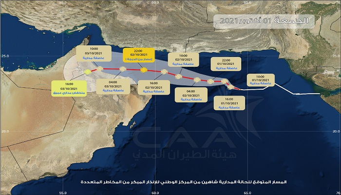
CAA on Friday, October 1, 2021 announced:
The centre of the tropical cyclone (Shaheen) is about 500 km from Muscat Governorate and continues its movement towards the coastal areas of Oman Sea, Civil Aviation Authority (CAA) said.
"Latest satellite images and weather charts analysis at the National Multi Hazards Early Warning Centre indicates that the tropical storm (Shaheen) has intensified into tropical cyclone (category 1) and is located at longitude 63.5 ° E and latitude 23.4 ° N . The tropical cyclone continues to move towards the coastal areas of Oman Sea with estimated surface wind speed around the centre between 64 and 82 knots (118 to 151 km/hr)," CAA said in alert No. 2 on tropical cyclone over the Arabian Sea
The centre of the cyclone is about 500 km away from Muscat Governorate and the closest convective clouds band associated with the cyclone is about 350 km.
The system is expected to move towards the coastal areas from Muscat to north Al Batinah Governorates. The cyclone is expected to directly impact the coastal areas from Muscat to north Al Batinah Governorates starting from Sunday morning. Strong winds and heavy rain ranging between 200 and 600 millimetres are likely to cause severe flash floods over Governorates of North Al Batinah, South Al Batinah, Muscat, Al Dhahira, Al Buraimi and Al Dakhiliyah may extend to the Governorates of Musandam, North Sharqiyah and South Al Sharqiyah
Sea condition is expected to be very rough over the coastal areas between South Al Sharqiyah and Musandam Governorates with maximum wave height ranging between 8 and 12 metres. In addition, low level coastal areas may be inundated.
The sea will be rough along the rest of Omani coasts with maximum wave height between 3 and 5 metres.
The Civil Aviation Authority advices the public to take proper precautions, stay away from the low lying areas and avoid crossing wadis. The Authority also advises the fishermen and sea goers to avoid venturing into the sea and follow the latest bulletins from the National Multi Hazard Early Warning Centre.