Friday 13 / November / 2026
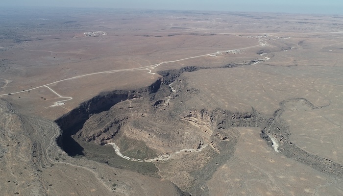
Muscat: The International Union of Geological Sciences (IUGS) has included the "Karst Landscapes and Tufa Deposits" in the Dhofar Mountains in its third list of the Top 100 Geological Heritage Sites in the world, in an international recognition that enhances the Sultanate of Oman's position on the geological tourism map.
The IUGS selected the "Karst Landscapes and Tufa Deposits in the Dhofar Mountains" within the third list of the most important 100 geological heritage sites in the world, in a new international recognition of the unique scientific and heritage value of this site located in the south of the Sultanate of Oman, giving it a stronger presence on the map of geological tourism and scientific research globally.
The announcement was made on 6 November in the Portuguese city of Loulé, during a geological heritage event organised by Algarvensis Geopark, with the participation of 156 experts from 49 countries.
The 100 sites in the new list are distributed across 47 countries, including six sites in the Middle East, and include famous landmarks such as Mount Fuji in Japan, the fjords of Norway, the San Andreas Fault in the United States, Mount Aconcagua in Argentina, and the Chocolate Hills in the Philippines.
The third list is an extension of two previous lists, the first announced in Zumaia, Spain in 2022, and the second during the 37th International Geological Congress in Busan, Republic of Korea in 2024. More than 1,000 experts from 90 countries and 20 international organisations have contributed to the programme since its launch, through nominating sites, evaluating their scientific value and participating in their selection.
The selected site is located in the Dhofar Mountains, which date back to the geological period from the Neogene to the Quaternary.
The Union identified its scientific importance in the fields of geomorphology and active geological processes, and tectonics. The site file describes it as an exceptional example of the evolution of karst phenomena and tufa deposition in the Arabian Peninsula within a semi-arid environment, and a witness to the interaction between subsurface and surface processes in shaping the Earth's surface.
The most distinctive feature of the site is the limestone tufa dams, which formed by the deposition of calcium carbonate from springs fed by groundwater reservoirs, damming the valleys since humid stages of the Middle Pleistocene, and some of which are still seasonally active during the khareef. The Wadi Darbat dam is the most prominent example; it extends about 800 metres and exceeds 100 metres in height, and the site file describes the grandeur of these dams as unmatched anywhere else in the world.
The Dhofar Mountains consist of pre-Cambrian rocks topped by layers of limestone, raised by tectonic processes linked to the opening of the Gulf of Aden to form a high plateau, ending in the south with a towering escarpment exceeding 1,000 metres above sea level, sloping in some places directly to the Arabian Sea, while in other places it is bordered by a coastal plain reaching about 20 kilometres in width near Salalah. In contrast, climatic factors contributed to dissolving the limestone and forming a karst plateau interspersed with karst pits, cones and sinkholes, cut by deep valleys embracing caves and rock shelters that are remnants of a subterranean karst system revealed by erosion.
Scientifically, interest in the Dhofar Mountains began with studying its tectonic structure and its relationship to plate movement between Africa and the Arabian Peninsula, then recent research turned to geomorphological and palaeoclimatic studies, using cave deposits, speleothems and carbonate tufa to reconstruct climate changes in the region during the late Quaternary, and helping also to understand early human settlement in its caves.
The nomination file was prepared by an international research team led by researcher Andrea Zerboni from the University of Milan in Italy, with the participation of Mohammed bin Hilal Al Kindi from the Earth Sciences Consultancy Centre in Muscat, alongside researchers from universities and scientific institutions in Italy, France and the United States.
HE Eng. Ibrahim bin Said Al Kharousi, Undersecretary of the Ministry of Heritage and Tourism for Heritage, said: "The selection of the Dhofar Mountains among the top 100 geological heritage sites in the world represents international recognition of the unique natural and geological heritage that the Sultanate of Oman abounds with, and confirms that heritage is not limited to what man has made, but includes what nature has created over long geological eras. The Ministry is keen to preserve this heritage, highlight it and introduce it to the community and visitors, and will work with its partners to employ this achievement in supporting geological tourism and scientific research, and raising awareness of the importance of protecting our natural sites for future generations."
Dr. Mohammed bin Hilal Al Kindi, Chairman of the Earth Sciences Consultancy Centre, said: "The scientific value of the Dhofar Mountains lies in that they combine in one place the effect of both tectonic and climatic processes; the opening of the Gulf of Aden raised the plateau and formed its southern edge, while climatic conditions shaped the karst plateau and tufa dams.
"These dams, including the Wadi Darbat dam, which extends about 800 metres and exceeds 100 metres in height, are a record of humid stages dating back to the Middle Pleistocene, and are still seasonally active with the khareef. The caves and their deposits and tufa also preserve evidence relied upon by researchers in reconstructing climate changes in the region during the late Quaternary, making these mountains an open natural laboratory for earth sciences."
The recognition of the Dhofar Mountains is expected to be reflected in enriching the tourism product in Dhofar Governorate, attracting researchers and those interested in earth sciences, and supporting efforts to protect the natural and geological heritage in the Sultanate of Oman and raise awareness of it.