Friday 31 / July / 2026
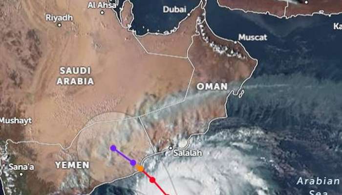
Muscat: The latest satellite images show advection of clouds and varied intensity rains began to affect parts of Dhofar Governorate during the last few hours as associating impacts of the Tropical Cyclone (Tej).
According to the Warning (2) issued by the Civil Aviation Authority (CAA), weather charts analysis at the National Multi Hazard Early Warning Centre indicate that the Tropical Cyclone Category 3 (Tej) is cantered on latitude 12.9 °N and Longitude 54.7 °E. The centre of the cyclone is around 450 km away from the nearest coast of Oman. Wind speed around the centre is estimated to be between 100 to 112 knots, and the nearest rainy cloud mass is estimated to be 140 km away from the coasts (Wilayat of Sadah).
The forecasts suggest that the cyclone will continue to move west northwest towards the coasts of Dhofar Governorate and the Republic of Yemen (AI Mahra). It is likely to further intensify into a category (4) cyclone within the upcoming 24 hours.
The direct impact of the cyclone is expected to increase on Dhofar and AI Wusta governorates during the next hours of tonight (Sunday, 22 October 2023) with heavy rainfall (50 - 150 mm) with expected flow of wadis. The sea is expected to be very rough ranging between (4 – 7 meters). In addition, storm surge might cause sea water inundation over low level coastal areas.
CAA advices all to take maximum precautions, avoid to crossing wadis and avoid low-lying areas. It also advices to avoid venturing into the sea during this period.