
Friday 31 / July / 2026
Muscat: Here are the latest updates on the tropical situation- Cyclone Biparjoy. Read to find out what is it's characteristics, trajectory and how it may impact the atmosphere of the Sultanate of Oman.
(2:00 pm): No direct effect for the next three days in Oman
No direct effects expected in the atmosphere of Oman for the next three days, said the Civil Aviation Authority in Report No. (3) regarding the Tropical situation in the Arabian Sea. There are low chances of the Sultanate being affected by the situation in general, added the CAA.
CAA said: “The latest satellite images and analysis of the National Early Warning Centre for Multiple Hazards show that the tropical state continues to be classified as a Cat. 1 tropical cyclone. It is centered in the middle of the Arabian Sea at latitude 14.8 north and longitude 66.2 east, and it is about 1020 km from the coast of Oman.”
“The wind speed is estimated around the centre ranging from 64 to 70 knots, with no direct effects on the airspace of the Sultanate of Oman for the next three days.”
Tropical status details:
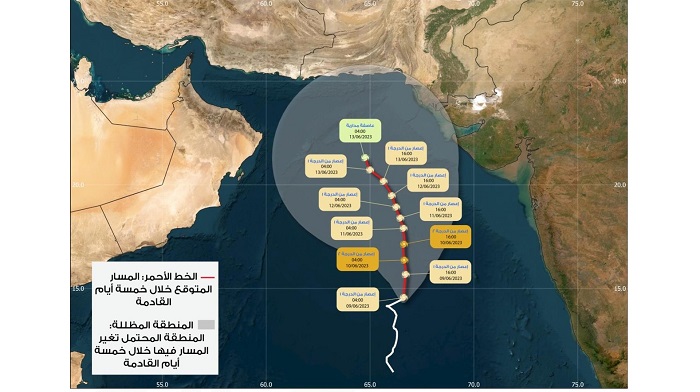
On Friday, June 9, 2023, The tropical state is expected to continue as a hurricane of the first degree, and the wind speed around the centre is estimated to be from 64 to 70 knots, accompanied by the flow of high and medium clouds - on the coasts overlooking the Arabian Sea. There is an an alert of high sea waves on the coasts of the governorates of Al Sharqiyah, Al Wusta and Dhofar in the evening, and the maximum wave height may reach 3-5 meters.
On Saturday, June 10, 2023, there is a possibility of the tropical situation developing into a second-degree hurricane, and the wind speed around the centre is estimated to be from 83 to 90 knots, accompanied by an influx of high and medium clouds on the coasts overlooking the Arabian Sea, with continued warning of sea wave rise on the coasts of the governorates of South Al Sharqiyah, Al Wusta, and Dhofar. The maximum wave height may reach 3-5 meters.
On Sunday, June 11, 2023, the tropical state of is expected to decline to a hurricane of the first degree, accompanied by the flow of high and medium winds on the coasts overlooking the Arabian Sea and the Sea of Oman. Warning of high sea waves on the coasts of the governorates of Al Sharqiyah, Al Wusta and Dhofar, and the maximum wave height reaching 4-6 meters to continue, along with chances of sea water extending to the low coastal area.
EARLIER
(9:30 am): Oman Meteorology said in its report about the latest developments in the tropical situation in the Arabian Sea that so far Cyclone Biparjoy has been classified as a Cat 1 tropical cyclone, and its centre is 1020 km away from the Sultanate of Oman's coast.
On Friday, June 9, 2023, the location of Cyclone Biparjoy is in Latitude 14.8 North and Longitude 66.4 East. The associated clouds are 630 km away from the Omani coast, which was 550 km away on Thursday. The wind strength is 65-70 knots, and the expected direction of the cyclone is north towards the centre of the Arabian Sea.
Will it impact Oman's atmosphere?
Most likely, the chances of Cyclone Biparjoy heading towards Pakistan or India or fading into the sea are high, said Abdullah bin Rashid Al-Khaduri, Director General of Meteorology.
He added in an interview with Oman national TV that, the cyclone is moving slowly towards the centre of the Arabian Sea and is still classified as a Cat. 1 cyclone. The chances of Oman being affected by it are still weak, but it is possible, and we are preparing for all possibilities.
It is noteworthy that the Civil Aviation Authority published on Thursday June, 8, 2023 a summary of the expectations of the weather situation in Arabian Sea for today, Friday, June 9, 2023 as follows:
- The flow of high clouds over the coastal areas overlooking the Arabian Sea
- Chances of clouds forming over the Hajar Mountains post noon
- Chances of formation of low clouds and fog in parts of the coasts of the South Al Sharqiyah, Al Wusta and Dhofar governorates
- Opportunities for dust storms in desert and open areas
-Low level horizontal visibility during fog and dust storms, in addition to rough waves on the coasts of the Arabian Sea (3-5 meters).
(Saturday, June 10, 2023)
(3:00 PM): Oman Meteorology and CAA issue updates, expected weather conditions for next three days
The latest satellite images and analyses of the National Centre for Early Warning of Multiple Hazards show the concentration of the first-degree tropical cyclone in the middle of the Arabian Sea at latitude 16.5 North and longitude 67.4 East. It is about 1050 km from the coast of the Sultanate of Oman, and the wind speed around the centre is estimated at 65 to 80 knots, Oman Meteorology said.
The Civil Aviation Authority issued indication of the expected weather conditions during the next three days
Sunday, June 11, 2023:
The flow of high and medium clouds with a sea wave height of (4-6) metres on the coasts overlooking the Arabian Sea.
Monday, June 12, 2023:
The flow of high and medium clouds with a sea wave height of (4-6) metres on the coasts overlooking the Arabian Sea, and 2-3 metres on the coasts of the Sea of Oman.
Tuesday, June 13, 2023:
The flow of high and medium clouds with a sea wave height of (3-5) metres on the coasts overlooking the Arabian Sea, and 2-3 metres on the Sea of Oman.