Saturday 25 / July / 2026
Muscat: A study conducted by a team from the Sultan Qaboos University on the areas in Oman most prone to cyclones can help plan for future adverse weather events.
Published in July, the research studied the effect of cyclones in the governorates of Muscat, Al Batinah and Al Sharqiyah, which are at high to very high risk of tropical cyclones in the Arabian Peninsula. The study, titled “Geospatial Modelling of Tropical Cyclone Risk Along the Northeast Coast of Oman: Marine Hazard Mitigation and Management Policies,” was done by Shawky Mansour, Stephen Darby, Julian Leyland and Peter M Atkinson.
The researchers said, “Globally, an increasing and more dispersed population, as well as climate change, have led to growing impacts of environmental hazards, particularly across areas prone to extreme weather events such as tropical cyclones. Tropical cyclones frequently cause fatalities, damage to infrastructure, and disruption to economic activities.”
They added, “The north and northeast regions of Oman, particularly the Oman sea coast, are prone to the storm surges, windstorms and extreme precipitation events associated with these tropical storms. However, integrated spatial risk assessments, for the purpose of mapping cyclone risk at subnational geographic scales, have not yet been developed in this area.”
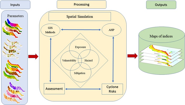
They explained, “The study evaluates and maps cyclone risk using four independent components: hazard, exposure, vulnerability and mitigation capacity. An integrated risk index was calculated using a geographical information system (GIS) and an analytical hierarchical process (AHP) technique, based on a geodatabase including 17 variables (i.e., GIS data layers) and criteria, with rank and weight scores for each criterion.” The resulting risk assessment reveals the spatial variation in cyclone risk across the study area and highlights how this variation is controlled by variations in physical hazard, exposure, vulnerability and emergency preparedness.
The risk maps reveal that despite their perceived adaptive capacity for disaster mitigation, the population and assets in low-lying lands situated near the coastline in the east of Muscat, as well as the South Al Batinah Governorate, are at high risk due to cyclones.
Furthermore, the coastal zones of the urban wilayats of the Muscat Governorate were also found to be at high to very high risk. This study has several policy implications and can provide effective guidelines for natural hazard preparedness and mitigation across the northern coasts of Oman.