Saturday 11 / April / 2026
Latest: Tropical storm Hika set to make landfall today
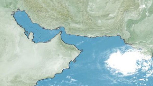
Muscat: The tropical depression that is moving westwards off the Indian coast and towards the centre of the Arabian Sea has developed into a tropical storm and has been named ‘Hikaa’.
Public Authority for Civil Aviation (PACA) had said that although the storm was expected to weaken as it moved towards the Omani coastline, it will still affect Al Sharqiyah and Al Wusta.
Oman’s National Ferries Company has said it will suspend its service on Shannah-Masirah route from this evening until further notice.
A statement from NFC said, “In view of the developing Cyclonic Storm Hikaa in the Arabian Sea and associated adverse weather conditions, NFC temporarily suspends trips along Shannah–Masirah route. The trips suspension is for passengers’ safety and comfort, shall take effect this evening, Monday, 23rd September.”
The National Multi-Hazard Early Warning Centre said that the storm was located at “longitude 64.1 degrees east and latitude 20.3 degrees north, with an estimated surface wind speed around the centre between 60 to 75 km/hr.
The storm is about 540 km away from Masirah Island. The tropical storm continues to move towards the coasts of Al Sharqiyah and Al Wusta Governorates. Numerical weather predications indicate possible gradual weakening of the storm while approaching the coastal areas of the Sultanate.”
PACA added, “The direct effect of the storm is expected to reach South Sharqiyah and Al Wusta by tomorrow evening (Tuesday, 24 September 2019) associated with heavy rain with amounts ranging between 30 and 60mm and fresh winds ranging between 25 and 30 knots. A rough sea state is expected over the coastal areas of South Al Sharqiyah and Al Wusta with a maximum wave height of between three and six metres, with chances of sea water inundation over low-level coastal areas. The sea state will be moderate for the rest of the coastal areas with a maximum wave height of between 1.5 and 2.5 metres.”
The Bureau of Meteorology of the Australian government has explained how cyclones and tropical storms get their names.
“People ask us all the time how we come up with the names for tropical cyclones,” said Andrea Peace, a senior meteorologist at the BOM. “We name tropical cyclones so that we can easily communicate information about them with the community and also to reduce confusion if multiple tropical cyclones occur at once.”
It was meteorologist Clement Wragg who first named tropical storms way back in 1887, naming them for letters of the Greek alphabet, mythological creatures and political characters. That lasted until 1902, when Wragg left the field, and it was only in the 1960s that the process was formalised.
“Names can be reused, but when a cyclone causes a significant amount of damage or loss, we permanently retire the name,” said Peace. “And if a name comes up that matches a prominent person of the day, we move to the next name to avoid confusion or offence. If a cyclone forms in another region, say the Pacific Islands or the Indian Ocean region, it keeps the original name that was given by that region’s weather agency. An example of this is cyclone Yasi, which originated near Fiji.”
Oman’s PACA asked people in the country to exercise caution during the approach of Hikaa, to stay away from low-lying areas and avoiding crossing wadis. It also advises fishermen and sailors to avoid venturing into the sea and to follow the latest and updated bulletins from the National Multi Hazard Early Warning Centre.