Saturday 27 / June / 2026
Muscat: Mohamed bin Zayed University of Artificial Intelligence (MBZUAI) is investigating how artificial intelligence (AI) can provide solutions for urban planning globally to help tackle the increase in extreme weather events due to climate change.
Following the recent record-breaking April 16 weather system experienced across the Gulf region, a team of MBZUAI researchers and students led by Associate Professor of Computer Vision, Dr. Salman Khan, have combined AI and computer vision techniques to create an automated satellite data analysis prototype for flood assessment.
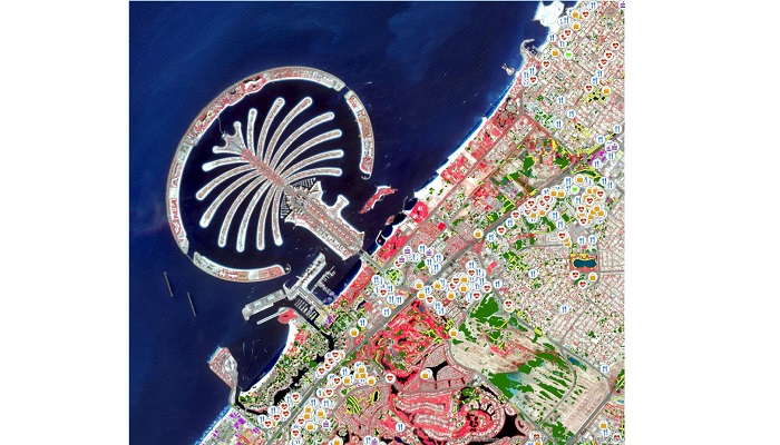
Using three localized case studies for the Palm in Dubai, the Musaffah area in Abu Dhabi, and AlBuraimi region in Oman, the researchers have utilized available spatial satellite data to compare remotely sensed imagery before and after the storm. The analysis aims to provide a useful change detection tool for local municipalities and authorities in rapidly assessing the impact of heavy rains.
The analysis tool can precisely locate which roads are heavily impacted by water accumulation following extreme rain events (shown as yellow lines overlapping flooding areas), and pinpoint affected critical infrastructure such as hospitals, schools, restaurants and malls, industrial complexes, residential areas, and population clusters which may be most at danger.
Currently, the model is in its early stages and relies on AI models and free, publicly available data including Sentinel-2 imagery at 10-meter resolution and OpenStreetMap, where volunteers worldwide contribute geographic information like streets, points of interest, and landmarks with community efforts to ensure data authenticity.
“From our analysis of the Dubai case study area, we found that 140 kilometers out of the 2963 kilometers was impacted by rain, including primary, residential, service, and highways,” Dr. Khan said. “In this imagery, from the color depiction, we can estimate the depth of the water. We noted a roughly six square kilometer built-up area in this study to be flooded after the April 16 rain, equating to 6.4% of the total built-up area.”
“Our hope is that such automated tools and analysis can help local authorities assess the critical locations that need more attention after extreme weather events and analyze the recovery process over time. For example, our analysis pinpoints 460 affected cafes, 75 pharmacies/clinics, four malls, and 11 educational institutions: vital information for rescue, recovery, and future planning.”
“The case studies can be expanded to map recovery and study how long it takes for flooded areas to dry up as a part of temporal analysis. With enough historical data, AI can then be used to analyze how a forecast rain event may impact urban areas across the world, offering more accurate warnings to residents.”
Combined with more frequent, higher resolution satellite imagery, an early warning system may be obtainable for specific areas. Such foundation AI models for land-use mapping and change detection can be used for other applications, with MBZUAI and IBM currently working on AI-enabled solutions to detect urban heat islands by identifying areas with excessive heat and correlating factors which contribute. The solution will help city planners, municipalities, and residents to mitigate the worst effects of heat islands, making cities more livable amid unpredictable weather patterns.
In the future, Dr. Khan said MBZUAI aims to expand the flood study to include more areas across the Gulf region and engage with government and industry organizations to tailor and improve the tool through the addition of further data parameters such as existing drainage networks, rescue center locations, and 3D sensors for more precise water level information.
“We will also investigate how the accumulation of water affects population density and urbanization,” Dr. Khan added. “The information and analysis we provide can help authorities in many ways, like working with communities to make them more resilient, planning infrastructure that can handle these events, and creating policies to adapt to long-term water resource and infrastructure changes.”
The university plans to connect with UAE government authorities such as the Environment Agency – Abu Dhabi (EAD) and Department of Municipalities and Transport (DMT), municipalities, local developers such as Aldar and Emaar, and the UAE flood assessment committee to demonstrate their findings.