Sunday 05 / July / 2026
Muscat: Measures have been taken all across parts Oman that are expected to bear the brunt of tropical storm Shaheen, which is set to make landfall at 10 am on Sunday.
Shaheen, which evolved into a category one cyclone while over the Arabian Sea, is expected to devolve back into a storm as it moves landward. Nevertheless, people have been asked to remain extremely cautious, and to avoid going out unless extremely necessary.
Shaheen will be accompanied by high-speed winds between the range of 30-60 knots, and very heavy thunderstorm (200 to 500 mm), across much of northern Oman, including North and South Al Batinah, Muscat, Al Dhahirah, Al Buraimi, A’Dakhiliyah, and the coastal area of South Al Sharqiyah, according to the Civil Aviation Authority.
Musandam and North Al Sharqiyah governorates may be also affected by rains of varying intensity (30-80 mm) and moderate to active winds (15-25 knots). Shaheen, once it makes landfall, will move towards the Dhahirah governorate, when it will devolve further into a tropical depression.
The Sultan's Armed Forces affirmed their full readiness to deal with the cyclone. "The Sultan's Armed Forces confirm their complete readiness and harness their capabilities to contribute to dealing with the tropical situation Shaheen. It will provide all support and assistance to government agencies, including military, security, civil and other sectors in the Sultanate," Oman News Agency (ONA) said in a statement.
The National Committee for Emergency Management has issued guidelines for people to stay safe during the rough weather. “Follow the latest updates and news published by Oman’s official agencies,” said the NCEM advisory. “Make sure your vehicle’s petrol tank is full, and in case you are requested to evacuate from a location, kindly cooperate for your safety.”
“Stay at home if there is no evacuation requested – do not get out except in case of serious emergency,” added the body. “In case of an emergency, avoid unsafe roads and do not risk going through wadis.”
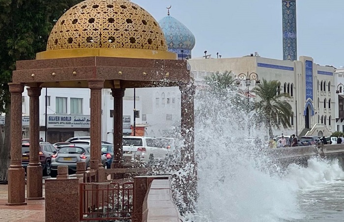
The sea will get very rough until the storm begins to decrease in intensity, with wave heights expected to reach between eight and 12 metres between South Sharqiyah and Musandam, and three and five metres in the other areas of the country.
“The tropical situation will witness sea levels rise, so avoid venturing out to sea, and stay away from low lying areas surrounding the coast,” added the NCEM.
Shelters have been set up in parts of the country that are most likely to be affected by the storm. Oman News Agency reports that a total of 37 centres have been organised in North Al Batinah alone: four of them are in Liwa, five in Khaboura, six each in Saham and Shinas, and eight in both Sohar and Suwaiq.
The NCEM has also announced the availability of five storm shelters in South Al Batinah, and a further six in South Al Sharqiyah.
The path taken by Shaheen is the rarest seen in Oman over more than 130 years, according to Hatrith Al Saifi, a historian in the country.
“The path drawn by weather models is the rarest since June 1890, or 131 years ago,” he said. “The weather at that time caused great damage. More than 100,000 palm trees were swept away, rain of up to 286mm was recorded, and waves in Muscat reached heights of up to six metres. The damage and heavy rains were felt as far away as Sohar.”
In the interests of people's safety, a two-day holiday has been declared for public and private-sector employees on Sunday and Monday. Many schools and universities will take their classes online, and bus and ferry routes have been suspended.
In case of an emergency, the NCEM can be contacted on 9999.